From Brunnen over the Rigi to Lucerne
37.7 kilometres and twelve hours of walking: this stage is the longest in the whole collection. It leads from Brunnen on Lake Lucerne over the Rigi all the way to Lucerne and demands 1,607 metres of ascent as well as very careful time planning.
The route from above
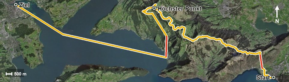
Open interactive map (zoom and pan)
Elevation profile
Route description
The starting point is the Brunnen boat landing at 435 metres. The climb begins at once and is the hardest part of the tour: 880 metres of ascent by kilometre 4.2, with a passage at around 55 per cent at kilometre 1.7. A cable car bridges the section from 437 to 1,131 metres.
Via Timpel and the Gätterlipass at kilometre 6.7 the path continues, gains a good 430 metres more in two further pushes and reaches Rigi Scheidegg via Rigi Burggeist at kilometre 9.2. After First, the highest point follows at kilometre 16.5 at 1,657 metres.
At kilometre 17.6 Rigi Kaltbad is reached. The long final part leads via Grubisbalm down to Vitznau and on to Lucerne, with two sections of the descent bridged by railways. Start and finish both lie at 435 metres.
Some sections require a sure step and sturdy footwear. For breaks there are five inns, among them the Bergrestaurant Timpelweid at kilometre 3, the Restaurant Gätterlipass at kilometre 6.7 and the Hotel Rigi Kaltbad at kilometre 19.3. The tour is recommended from June to October.
Grading
Good to know
Getting there / public transport
By public transport or boat to Brunnen; the hike starts at the boat landing. Current timetable at sbb.ch.
Food and drink
Bergrestaurant Timpelweid at kilometre 3, Restaurant Gätterlipass at kilometre 6.7, Berggasthaus Burggeist at kilometre 9.2, Kräuterhotel Edelweiss at kilometre 17.6 and Hotel Rigi Kaltbad at kilometre 19.3.
Best time of year
Recommended: Jun, Jul, Aug, Sep, Oct