From Morschach via Oberschönenbuch to Muotathal
20.8 kilometres, seven hours and 1,159 metres of ascent: this long route links Morschach with Muotathal and remains technically easy throughout. Start and finish lie at almost the same height; in between it gets hilly.
The route from above
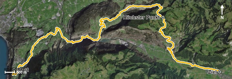
Open interactive map (zoom and pan)
Elevation profile
Route description
The starting point is Morschach at 632 metres. Via Dümlen, the Schwyzerhöhe and Eggeli the path first crosses undulating terrain, passes Mur and reaches Oberschönenbuch at kilometre 4.6.
After Fron and the Summerlaui the route crosses the Muota at kilometre 6.5 and leads through the Schrutenloch and the Chlingentobel. From kilometre 7.4 the long climb begins: first 253 metres of ascent by kilometre 10.8, then another 352 by kilometre 14.2.
At kilometre 14.1 the highest point is reached at 1,188 metres. The final part leads across the Mettelbach down to Muotathal at 610 metres. The elevation range is 651 metres.
The steepest passage is a mere 17 per cent, so technically the path remains straightforward. The challenge lies in the length: more than 20 kilometres with a good thousand metres of ascent call for fitness and realistic time planning. No refreshment stop is recorded along the route, so provisions belong in the rucksack. The tour is recommended from April to October.
Grading
Good to know
Getting there / public transport
By public transport to Morschach. Current timetable at sbb.ch.
Food and drink
No refreshment stop is recorded along the route. Take provisions for the whole day; there are restaurants in Morschach at the start and in Muotathal at the finish.
Best time of year
Recommended: Apr, May, Jun, Jul, Aug, Sep, Oct